30 km of SH2, north of Wellington
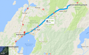
Look at this map in Google Maps.
Approximately 30 km of State Highway 2 (SH2) north of Wellington caters for commuter traffic from the Hutt Valley as well as being the second (of 2) major road link into the capital city.
Between 2015 and 2017 a grade-separated interchange was installed at the intersection with SH58 at Manor Park, and traffic lights were installed at Whakatiki Street, Upper Hutt.
TomTom data was used to do a “before and after” study of the impact of the changes on commuter traffic during the AM peak on a typical October weekday.
To allow for the comparison, separate queries (for October 2015 and October 2017) generated 2 sets of data from TomTom’s historical database. The data generated was for
- southbound (towards Wellington)
- in 15 minute intervals
- on Monday morning
- between 6.30am and 11.00am, during the AM commuter peak
- showing average and range of traffic speed during each interval
- showing average and range of travel time during each interval
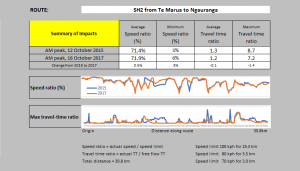
The graph is just one example of the information that can be extracted from the data. This example shows “before and after” speed and travel time ratios along 30 km of SH2, well before and well after the Manor Park and Whakatiki Street intersections where the upgrades occurred.

